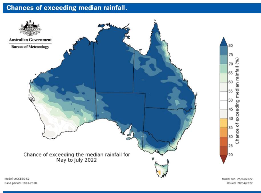
This year is shaping up as one dominated by a persistent La Nina in the Pacific - weakening although still likely to have an effect and a probably weakly negative Indian Ocean Dipole developing in the coming months. Although these features are favoured to be fairly weak, both are often responsible for at least slightly above average rainfall in many parts of Australia. With both these features simultaneously influencing our weather the chances are good for a least average rainfall in the coming six months over large parts of the continent with only the south west of WA and Tasmania missing out.
Subscribe now for unlimited access to all our agricultural news
across the nation
or signup to continue reading
The significant rain along many parts of the east coast in recent months is unlikely to be repeated but a wider area will now receive good rains with the Indian Ocean coming into play for the first time this year.
As I have noted previously, a weak La Nina and a weak IOD over winter do not necessarily bring widespread above average rainfall because moisture availability decreases with temperature in the winter months. However above average rainfall is more likely than not and this will be the case for much of this year.
One of the reasons for a little caution in predictions of continued wetter than normal weather is that the current La Nina event continues to weaken, with oceanic indicators approaching neutral levels but the atmospheric indicators remain above La Nina thresholds, meaning La Nina's influence continues. Sea surface temperatures in the tropical Pacific have been near neutral levels in recent weeks but in the atmosphere, stronger than average trade winds in the western Pacific and decreased cloudiness across the tropical Pacific region, as well as a strongly positive Southern Oscillation Index all point to La Nina levels being maintained, hence a little conflicting.
What continues to change, however, is the set-up over the Indian Ocean. Projections for the IOD are indicating a negative IOD developing in the coming months and this is reinforced by a consistency across most international models. Hence the assessment which increases the chances of above average winter-spring rainfall for much of Australia.
To the north, the Madden-Julian Oscillation is weak and will have little influence on our weather for the rest of the season, while to the south, the Southern Annular Mode index is temporarily fluctuating around neutral but is forecast to be negative for parts of the first two weeks of May, which may provide a reprieve for the east coast and bring needed rain to southern Victoria and Tasmania for a change.
Further reading:
Have you signed up to The Land's free daily newsletter? Register below to make sure you are up to date with everything that's important to NSW agriculture.

